- Title
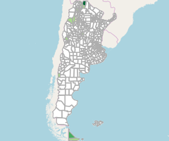
- Indice de magnitud de aluviones por década (1970-2009)
- Abstract
Valor máximo que asume el índice de magnitud de aluviones por departamento/partido en las decadas de (1970, 1980, 1990 y 2000)
Frecuencia de actualización: Anual
- License
- Open Data Commons Open Database License / OSM (ODbL/OSM)
-
+ You are free to copy, distribute, transmit and adapt our data, as long as you credit OpenStreetMap and its contributors
+ If you alter or build upon our data, you may distribute the result only under the same licence.
+ For more info see http://www.openstreetmap.org/copyright. - Publication Date
- Jan. 10, 2022, 3:52 p.m.
- Type
- Vector Data
- Keywords
-
- Aluviones
- Amenazas (de origen natural)
- Departamentos
- Indice
- Daño
- Sub Categoría Visor
- Area Temática
- Escala
- Categoría Visor
- Etiqueta Potencial Uso
- Categoría Geomop
- Subcategoría Geomop
- Programa de Trabajo
- Category
- Environment
- Environmental resources, protection and conservation. Examples: environmental pollution, waste storage and treatment, environmental impact assessment, monitoring environmental risk, nature reserves, landscape.
- Regions
- Global, Argentina
- Approved
- Yes
- Published
- Yes
- Featured
- No
- Group
- Dirección Nacional de Programación y Coordinación de la Obra Pública
- DOI
- None
- Attribution
- Elaboración propia en base al Centro de Estudios Sociales y Ambientales (CENTRO, 2012) - DesInventar Argentina 1970 - 2010 (Sistema de Inventario de Desastres)
- Name
- Julián Gonzalez Duran (jgd_planificacion)
- juliangonzduran@gmail.com
- Position
- None
- Organization
- None
- Location
- Voice
- None
- Fax
- None
- Identification Image
-


- Spatial Extent
- ---
- Projection System
- EPSG:4326
- Extension x0
- -73.572705
- Extension x1
- -53.639652
- Extension y0
- -55.047227
- Extension y1
- -21.778451
- Maintenance Frequency
- Data Is Updated As Deemed Necessary
- Restrictions
- exclusive right to the publication, production, or sale of the rights to a literary, dramatic, musical, or artistic work, or to the use of a commercial print or label, granted by law for a specified period of time to an author, composer, artist, distributor
- Language
- Spanish
- Supplemental Information
No information provided
- Spatial Representation Type
- vector data is used to represent geographic data
- Name
- geomop
- Position
- None
- Organization
- None
- Location
- Voice
- None
- Fax
- None
- Link Online
- /layers/geonode_data:geonode:mrapis_aluviones_ide
- Metadata Page
- /layers/geonode_data:geonode:mrapis_aluviones_ide/metadata_detail
- Indice de magnitud de aluviones por década (1970-2009).pdf
- Thumbnail
- Indice de magnitud de aluviones por década (1970-2009).png
- Shapefile Comprimido
- Indice de magnitud de aluviones por década (1970-2009).zip
- GML 2.0
- Indice de magnitud de aluviones por década (1970-2009).gml
- GML 3.1.1
- Indice de magnitud de aluviones por década (1970-2009).gml
- CSV
- Indice de magnitud de aluviones por década (1970-2009).csv
- Excel
- Indice de magnitud de aluviones por década (1970-2009).excel
- GeoJSON
- Indice de magnitud de aluviones por década (1970-2009).json
- Zipped Shapefile
- Indice de magnitud de aluviones por década (1970-2009).zip
- Legend
- Indice de magnitud de aluviones por década (1970-2009).png
- PNG
- Indice de magnitud de aluviones por década (1970-2009).png
- JPEG
- Indice de magnitud de aluviones por década (1970-2009).jpg
- OGC WMS: geonode Service
- Geoservice OGC:WMS
- OGC WFS: geonode Service
- Geoservice OGC:WFS
- Name
- geomop
- Position
- None
- Organization
- None
- Location
- Voice
- None
- Fax
- None